Virtually all schools and public offices closed, residents advised to stay home
Updated: 3:21p.m.
By Mike McGann, Editor, The Times
 Make no mistake, Hurricane Sandy is coming — headed directly at Chester County, sometime late Monday.
The short form is this: if you can stay home, stay home. Travel is expected to become extremely hazardous as the day wears on, as winds rise and objects become airborne.
The storm is expected to make landfall south of Atlantic City at around 6 p.m. EDT. Best estimate for the storm’s eye to pass through southern Chester County is somewhere between 9 & 10 p.m. EDT. Those communities slightly north of the eye may face extremely high winds as the northern side of the counterclockwise system pushes through the area.
Flooding continues to be a major concern, with high tide expected around 8 p.m. tonight. Those in low-lying areas or flood-prone areas are being asked to evacuate. If you are in a safe place, you’re being asked to stay there, as travel is rapidly becoming more dangerous, as winds increase, debris flies and there is an added danger of tree fall.
Power outages are becoming more widespread, as a portion of Caln — Thorndale — is reported to be without power.
Check back for updates, we will be adding to this report as the day goes on.
The giant Category 1 hurricane storm made the predicted left turn early Monday morning and is slowly moving into The Times area, bringing heavy rain, wind and the potential for widespread power outages and flooding. It is expected to still be a hurricane when it strikes the area late Monday.
If you have news to share or tips, please send them to news@chescotimes.com
In Coatesville, City Hall is closed Monday, although emergency personnel will be on duty throughout the duration of the storm. Valley township has been issuing computerized calls to residents in low-lying areas announcing evacuations by 3 p.m., Monday.
City officials are reminding residents that have special needs that require electricity should contact the Coatesville Emergency Operations Center (EOC) at 610-384-0300 extension 0. You may also contact the EOC at 610-384-0300 extension 0 to report other non-emergency storm related problems including but not limited to flooded roadways, downed trees, power outages etc.
In the event of any emergency, though, they remind city residents to call 911.
Travel by roadway is becoming increasingly dangerous and not advised. Roadway flooding has been reported in a number of areas in the county. Power outages are beginning to pop up ahead of the worst of the storm, which is expected to be Monday evening into Tuesday.
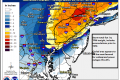
As Monday continues, rain and wind will increase as the eye of the storm passes over Atlantic City and heads almost directly over Chester County. As much as a foot of rain could fall, combined with high tides and full moon, leading to flooding throughout the area. Sustained winds are expected to be as high as 75 MPH — for an extended period of time, as long as 36 hours.![]()
![]()
Because trees and branches are expected to be downed, there are likely to be widespread power outages. Government officials are reminding residents to call PECO at 1-800-841-4141. Do not call 911 for power outages, only use that number for emergencies.
The National Weather Service has issued a severe flood alert for most of the county. Drivers — and only those who must be out, should be out — should not drive into flooded roadways.
With all Chester County schools and colleges closed, many business shutting down, local, county and state officials have one message for virtually all residents: stay home. While only the City of Coatesville as of now has a formal curfew — no one is allowed to be out after 7 p.m. Monday night through 7 a.m. Tuesday morning — officials are asking people to stay off the roads if possible. While there are no formal bans on travel, residents are advised to remain in shelter unless absolutely necessary.
Evacuations of people in flood-prone areas are being suggested — with two shelters open in the county, at Avon Grove High School and Lionville Middle School — and could be ordered later on Monday if flood waters rise in some low-lying areas near the Brandywine, Red Clay and White Clay creeks.
The entire Chester County government — except for emergency management and other emergency personnel — is closed: courts, offices and all non-essential operations on Monday and Tuesday.
Across the region, virtually everything is shut down: Philadelphia International Airport is closed on Monday, regional rail service has been suspended and virtually all SEPTA service is suspended.
According to the National Weather Service, Monday looks to be the peak of the storm for southeast Pennsylvania, but the slow-moving nature of the storm means highwinds and rain will persist through Tuesday and into Wednesday.