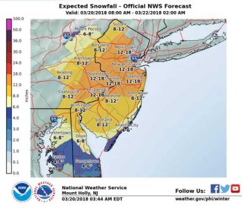
Spring sprung at exactly 12:15 p.m. today, but somehow the weather forecast missed it, as a powerful Nor’easter appears to be aiming right at Chester County. Unlike the last few storms where the county got off relatively easy, this one looks to pack a punch with as much as a foot (or more) of snow, ice, and winds during the next 36 hours.
According to the National Weather Service (NWS) Tuesday is just an opening act for the storm, which is expected to linger in the area well into Wednesday night.
On Tuesday, a wet mix of snow, rain and sleet is expected to fall, with accumulations of one to two inches across the county.
The heavy stuff — literally, as it is expected to be wet, heavy “heart attack” snow — will fall Wednesday, with rates of as much two to three inches per hour, according to the NWS. The snow is expected to accumulate on trees and wires, making power outages likely across the region. Total snowfall is expected to be between eight and 12 inches in the southern and western portion of the county and between 12 and 18 inches in the northeastern portion of the county. Those snowfall totals could vary a lot as the computer models remain a bit uncertain as to which areas will be hit hardest by the storm.
In anticipation of the storm closing in on Tuesday, local schools and government offices began to issue notices of cancellations and and early closings, with more expected as the day goes on. If the forecast holds, expect most county, local offices and schools to be closed on Wednesday.
Chester County Emergency Services offered a reminder of its 10 tips to help get through the storm safely:
- Sign up for ReadyChesCo to get weather alerts from us. If you are already signed up, ask your family, friends and neighbors to sign up today. Visit www.readychesco.org
- We want you to stay home during the storm, but if you think you will need to go out, prepare your car today. Fuel it up, have an emergency kit in your car including ice melt or cat litter. Remember to drive at a slower speed, slower steering and slower braking. Keep six car lengths between you and the car in front of you.
- If you have to be on the roads, “Don’t Crowd the Plow” Stay a safe distance behind the plow and don’t try to pass it.
- Prepare your home emergency supplies. If you used some of the items during the last storm, replenish them today so you are ready for this storm.
- We again remind you, if your electric power goes out, do not call 9-1-1. Call your utility company – PECO 1-800-841-4141; PPL 1-800-342-5775; Met-Ed 1-888-544-4877
- Check on your elderly neighbors today to see if they need anything. Then check on them during the storm to be sure they are ok.
- Pace yourself when shoveling. Many people die each year from heart attacks brought on by shoveling snow. If you need to, ask your neighbors to help.
- After taking your puppy out for a walk, wipe their paws. The chemicals used in ice melt is deadly to our pets.
- DES has been asked this question – What is the difference between a snow emergency and a state of emergency? Here is your answer: A Snow Emergency is a specific plan enacted by local government that places parking restrictions along pre-designated routes. A State of Emergency in PA – is a specific travel restrictions that means only authorized personnel are allowed to travel the roads.
- If we get a substantial amount of snow, please make sure that your hydrants and drains are clear. Clear 3 feet completely around the hydrant and 3 feet on either side of drain.


